The Lesner Bridge: History, Engineering, and What It Means to Shore Drive Virginia Beach
Every resident of Shore Drive crosses it. Every buyer driving the corridor for the first time notices it. The Lesner Bridge spanning the Lynnhaven Inlet at the mouth of the Chesapeake Bay is more than a crossing. It is the gateway to one of the most distinctive coastal communities in Hampton Roads, and it has a history and an engineering story worth knowing in full.
For residents of Lynnhaven Colony, Lynnhaven Shores, and Cape Henry Shores west of the bridge and for residents of Ocean Park, Baylake Pines, Baylake Beach, Aeries on the Bay, and Cape Story by the Sea to the east, the Lesner Bridge is not just infrastructure. It is the defining geographic and community anchor of the entire Shore Drive corridor.
Who Was John A. Lesner
The bridge carries the name of John Adam Lesner, born June 26, 1868 in Norfolk, Virginia. His father, a German immigrant, enlisted in the Union Army in 1861 and later served as sheriff of Norfolk County. The younger Lesner went on to serve three decades in the Virginia Senate as a Democratic politician, serving from 1908 to 1916 and again from 1923 until his death on July 5, 1938 at age 70. He is buried at Forest Lawn Cemetery in Norfolk.
According to Stephen Mansfield's book Princess Anne County and Virginia Beach: A Pictorial History, the Virginia General Assembly voted to name the bridge after Senator Lesner in recognition of his service on the State Highway Commission. It was through that role that Lesner became connected to the infrastructure of coastal Virginia and ultimately to the crossing at the Lynnhaven Inlet that now bears his name.
In February 2016 a proposal emerged to rename the bridge in honor of US Navy Admiral Jeremiah Denton, the former POW and Virginia Senator. Local residents and the Lesner family opposed the change. A public poll produced no support for renaming it. The bridge remains the John A. Lesner Bridge.
The First Bridge: 1928
The first bridge at the Lynnhaven Inlet crossing was a drawbridge constructed in 1928. It carried Shore Drive traffic, designated US Route 60, across the inlet at the mouth of the Chesapeake Bay, connecting the bay communities to the east with the broader city to the west.
For Shore Drive residents of that era, this crossing was the difference between being accessible and being isolated. The communities of Ocean Park, Baylake Pines, and what would become the broader Chic's Beach corridor were developing along the Chesapeake Bay shoreline during this period. The drawbridge made that development viable.
That original drawbridge served the corridor for 30 years before the growing population of coastal Virginia Beach made it functionally inadequate. In 1958 the drawbridge was replaced by what became the eastbound lanes of a new dual span structure. In 1967 the westbound lanes were constructed as a parallel span alongside it, completing the two bridge configuration that carried Shore Drive traffic for the next five decades.
For Shore Drive residents who remember those original spans, the experience of crossing was fundamentally different. The bridges were narrower, the shoulders were minimal, and there were no pedestrian or cycling accommodations. The Lynnhaven Inlet crossing was functional but it was not the community destination the current bridge has become.
The Case for Replacement
By the early 2010s the bridges constructed in 1958 and 1967 had been classified as structurally deficient and functionally obsolete. The highly corrosive coastal marine environment of the Lynnhaven Inlet had taken a significant toll on the structures over decades of exposure. The Lesner Bridge sits at the confluence of some of the fastest recorded tidal and storm surge currents in the Commonwealth of Virginia, an environment that accelerates deterioration of steel and concrete at a rate far beyond what inland bridges experience.
Annual bridge inspections showed the sufficiency rating declining steadily. Christopher J. Wojtowicz, construction bureau manager with the Virginia Beach Department of Public Works, described the situation to Roads and Bridges magazine: the city was doing annual inspections and seeing the sufficiency rating going down to a point where it was going to be very costly to do retrofits to the existing structure. The city could not afford to have a bridge that had been there for almost 50 years become subject to potential weight restrictions on a corridor carrying over 20,000 vehicles per day.
The City of Virginia Beach made the decision to replace both spans entirely rather than retrofit. The goal was a bridge with a 100 year design life that incorporated new aesthetics, new safety measures, and a multimodal design accommodating vehicles, pedestrians, and cyclists simultaneously. For Shore Drive residents who had lived without safe pedestrian and cycling infrastructure on the crossing for decades, that multimodal commitment was significant. That same commitment to pedestrian infrastructure is now continuing eastward with the Shore Drive Phase III construction project running from Vista Circle to Beech Street.
The Design: Reflections of the Bay
The city chose a segmental bridge design for the replacement. Segmental bridge construction uses precast concrete segments assembled on site, allowing for longer spans, more architectural curves, and a visual quality that fits the structure into the surrounding landscape rather than imposing on it. The design theme chosen in collaboration with the surrounding community was Reflections of the Bay.
This preference initially presented a challenge with the Virginia Department of Transportation. VDOT had reservations about segmental bridge construction at the time due to design flaws and maintenance issues on other segmental bridges in the state. The City of Virginia Beach was determined enough to move forward that it volunteered to pay for the engineering efforts itself rather than wait for state approval. Over time, through continued work with VDOT demonstrating the durability of the proposed design, approximately $80 million from the governor's transportation fund was ultimately secured to support the project.
The public was deeply involved in the design process. The community wanted a signature bridge, a genuine gateway structure that would reflect the natural beauty of the Lynnhaven Inlet and the Chesapeake Bay. What emerged from that process was a design that Shore Drive residents and visitors immediately recognized as something worth crossing for its own sake, not just to get from one side to the other.
The Engineering Team
The replacement project brought together a collection of specialized engineering and construction firms:
FIGG Bridge Engineers Inc. served as the primary designer of the new bridge structure. Clark Nexsen served as the engineer of record and was involved throughout the full project life cycle from inspection of the former structure through design of the replacement. RS&H won the construction, engineering, and inspection contract in 2013, representing one of its first major construction management projects outside the state of Florida. McLean Contracting Company served as the prime contractor for construction. GM2 Associates participated in the complex bridge design.
The LED lighting design was created by Randy Burkett Lighting Design, whose programmable system gave the City of Virginia Beach the ability to change the visual appearance of the bridge at any time. A 36 foot sculpture by artist Donald Lipski was installed on the pedestrian overlook, welcoming visitors and residents into the beauty and history of the Chesapeake Bay.
Construction: 2014 to 2018
Construction on the new westbound span started in June 2014. The westbound span opened to traffic in November 2016.
In December 2016, eastbound Shore Drive traffic was shifted onto the new westbound bridge while the existing original spans were demolished and construction began on the new eastbound bridge alongside it. On December 12, 2018, the new Lesner Bridge was officially opened to the public, reaching substantial completion after four years of active construction.
The construction contract value was $78.7 million. The total project cost including design, engineering, and related work was approximately $115 million.
For Shore Drive residents who lived through those four years of construction, the phasing required significant patience. The critical constraint throughout the entire project was that the bridge could never reduce traffic capacity. With over 20,000 vehicles crossing daily and the corridor serving as the primary connection for communities on both sides of the inlet, maintaining full lane capacity was non-negotiable. That requirement dictated that the first new bridge be designed and built to carry all four required lanes of traffic while the existing bridges were demolished and the second new bridge was constructed. This phasing approach extended the construction timeline significantly but preserved daily access throughout the project.
The Engineering Specifications
The new Lesner Bridge consists of twin precast concrete segmental box girder bridges. Here are the verified engineering specifications:
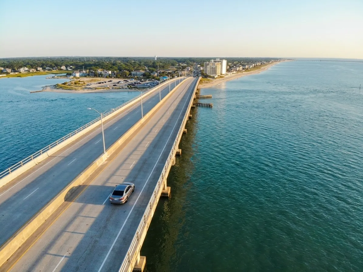
Each bridge is 1,575 feet long. Each bridge consists of 10 spans: nine approach spans at 150 feet each and one main channel span of 225 feet. Each bridge has nine piers and two abutments. The bridge provides 45 feet of vertical navigational clearance above mean high water. The horizontal clearance at the navigational channel is 225 feet. Each bridge carries two 12 foot travel lanes with 10 foot and 6 foot shoulders. Each bridge includes a 10 foot wide multiuse pathway separated from the vehicular lanes by a blue colored railing. The four lane divided roadway was designed to accommodate an additional lane in each direction in the future for a potential total of six lanes.
The Lynnhaven Inlet location presented specific engineering challenges beyond the typical coastal environment. The site is subject to some of the fastest recorded tidal and storm surge currents in the Commonwealth of Virginia. To address this, VDOT requested simulation of storm surge velocities and flood limits across the entire 45 square mile Lynnhaven River Basin before design was finalized. The project also required substantial coordination with multiple state and federal environmental regulatory agencies due to the ecological sensitivity of the Lynnhaven Inlet and its surrounding tidal wetlands.
The Materials Built for 100 Years
Achieving a 100 year design life in a coastal marine environment required material specifications well beyond standard bridge construction practice.
All reinforcing steel was either stainless steel or low chromium, low carbon alloy, both selected specifically for corrosion resistance in the aggressive chloride environment of the Lynnhaven Inlet. All concrete was designed to be low permeability concrete. Superstructure concrete was designed to achieve 8,000 PSI compressive strength. These specifications were among the highest quality material standards applied to any bridge project in Virginia at the time of construction.
To help offset the extended construction timeline required by the full lane capacity constraint, three of the four abutment foundations were modified from the originally designed four foot diameter drilled shafts requiring over 100 feet of depth to driven piles. This change reduced the number of days required to construct the foundations without adding cost to the project.
The Construction Method
The precast segmental structures were built using two distinct methods. Span-by-span construction was used for the nine standard 150 foot approach spans. Balanced cantilever construction was used for the longer 225 foot main channel span. Both methods were executed using the same overhead gantry system, an unusual engineering achievement given the significant difference in span length between the approach spans and the main channel crossing. Using a single gantry system for both construction methods without additional crane support was a distinctive feature of this project and a point of technical pride for the engineering team.
The Awards
The completed Lesner Bridge received significant industry recognition. The American Segmental Bridge Institute awarded it the 2019 Award of Excellence. Roads and Bridges magazine named it one of the Top Ten Bridges of 2019. The City of Virginia Beach received a Concrete Bridge Award of Excellence in 2020 for the project.
The Bridge Shore Drive Residents Have Today
The Lesner Bridge is Virginia Beach's signature structure. Its programmable LED lighting system allows the city to change the appearance of the bridge at any time. The illuminated abutments visible from the bay beach below have become one of the most distinctive evening landmarks on the entire Shore Drive corridor.
The 10 foot multiuse paths on both spans are used daily by runners, walkers, and cyclists from Lynnhaven Colony, Lynnhaven Shores, Cape Henry Shores, Ocean Park, Baylake Pines, Baylake Beach, Aeries on the Bay, and Cape Story by the Sea. The bridge connects both sides of the Shore Drive community in a way the original spans never could, with safe dedicated space for non-vehicle users that Shore Drive residents had been requesting for years. That pedestrian connectivity now continues east of the bridge with the Shore Drive Phase III project delivering sidewalks, bike lanes, and a shared use path all the way to Beech Street by late 2028.
The pedestrian overlook offers one of the most unobstructed views of the Lynnhaven Inlet, the Chesapeake Bay, and the surrounding coastal landscape available anywhere on the corridor. For residents who walk or run the bridge regularly, that overlook is part of the daily Shore Drive experience.
The bridge is visible from southbound lanes of the Chesapeake Bay Bridge-Tunnel, making it a genuine landmark for the entire Hampton Roads region. It was designed to accommodate an additional lane in each direction should future traffic volumes require it. It was built to last 100 years.
Every Shore Drive resident who crosses the Lesner Bridge crosses a structure that the surrounding community helped shape, that the City of Virginia Beach fought to fund, and that an engineering team built to stand for a century in one of the most demanding coastal environments in Virginia.
About the Author
John King is a Navy veteran and licensed real estate agent with Berkshire Hathaway RW Towne Realty, serving Hampton Roads including Virginia Beach, Norfolk, and Chesapeake. Known for his straightforward approach and market expertise. 📞 757-270-3994 📧 [email protected] 🌐 www.757King.com
Curious what your home is worth in today's market? Get a free home valuation and find out where you stand.
Sources and References:
City of Virginia Beach Department of Public Works
American Segmental Bridge Institute — asbi-assoc.org
RS&H — rsandh.com
Clark Nexsen — clarknexsen.com
FIGG Bridge Engineers — figgbridge.com
McLean Contracting Company — mcleancontracting.com
GM2 Associates — gm2inc.com
Roads and Bridges Magazine — roadsbridges.com
Wikipedia — Lesner Bridge: en.wikipedia.org/wiki/Lesner_Bridge
Wikipedia — John A. Lesner: en.wikipedia.org/wiki/John_A._Lesner
Stephen Mansfield — Princess Anne County and Virginia Beach: A Pictorial History, page 151
